
You are using an out of date browser. It may not display this or other websites correctly.
You should upgrade or use an alternative browser.
You should upgrade or use an alternative browser.
TS Sandy
- Thread starter texan
- Start date
texan
Well-Known Member
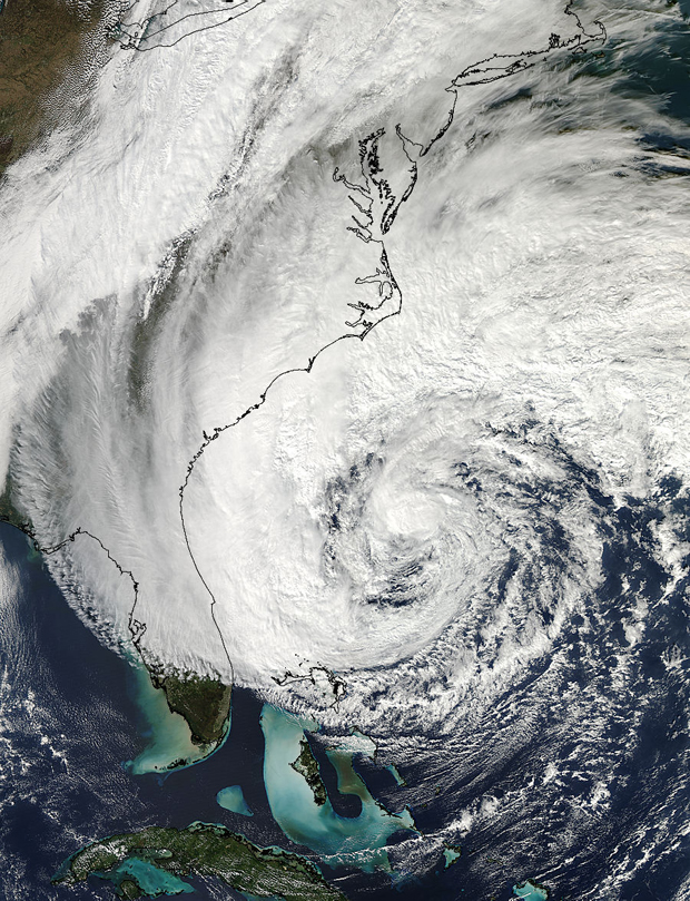
Hurricane Sandy is now the 2nd largest tropical cyclone in the Atlantic since 1988, tied with Hurricane Lili of 1996.
Sandy's tropical storm-force winds now extend 450 nautical miles from the center on the northeast side of the hurricane.
This is a very, very large storm, and I suspect the #1 spot (Olga of 2001) is in jeopardy, as well.
Sandy's tropical storm-force winds now extend 450 nautical miles from the center on the northeast side of the hurricane.
This is a very, very large storm, and I suspect the #1 spot (Olga of 2001) is in jeopardy, as well.
rod
Retired 22 years
Hurricane Sandy is now the 2nd largest tropical cyclone in the Atlantic since 1988, tied with Hurricane Lili of 1996.
Sandy's tropical storm-force winds now extend 450 nautical miles from the center on the northeast side of the hurricane.
This is a very, very large storm, and I suspect the #1 spot (Olga of 2001) is in jeopardy, as well.
I get the feeling that the politicians wished this was happening after the election. Its a perfect excuse to jack the price of gas back up again as we all know will happen as soon as the election is over----no matter who is elected.
menotyou
bella amicizia
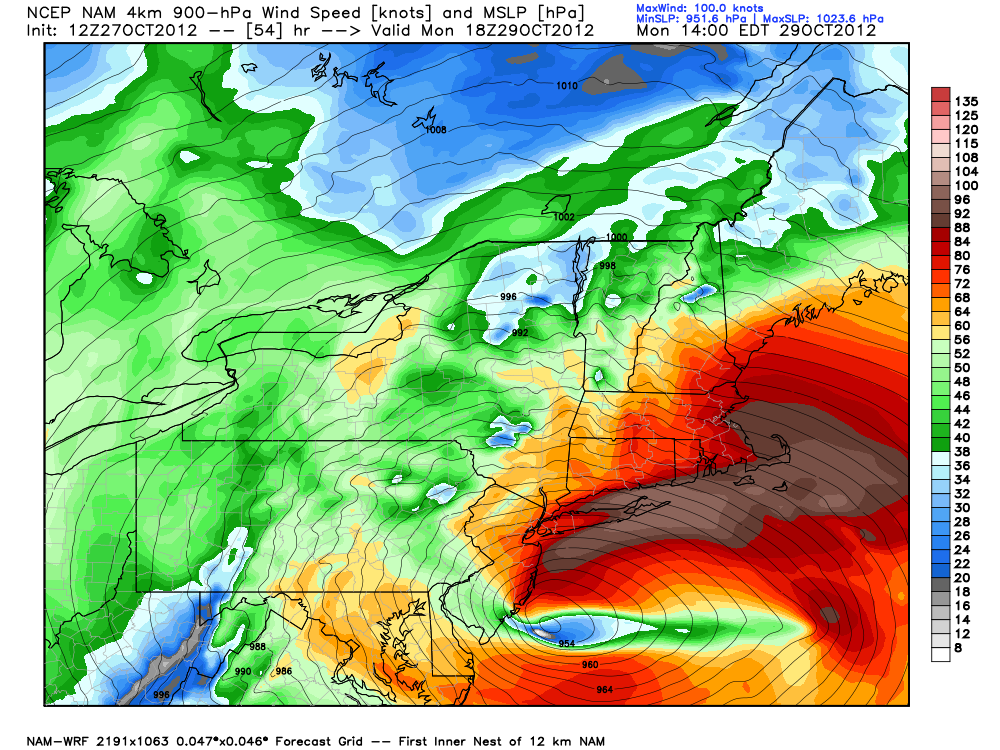
I love the little area of 60+ mile per hour winds just east of the lake. That's my weather.Wind predictions:
texan
Well-Known Member
I love the little area of 60+ mile per hour winds just east of the lake. That's my weather.
Just a prediction, who knows maybe it will not veer left.
menotyou
bella amicizia
I know, but the rain is here. Not to mention, we have another storm coming (New York Doppler Weather Radar Map - AccuWeather.com) and it is a low, as well. They will meet and create quite the mess, here. Just here they think 6-8 inches possible. I pray it stays in the form of rain.
Just a prediction, who knows maybe it will not veer left.
UnconTROLLed
perfection
LOL that's a better question for shareholders.So Sleeve, bottom line:
Are we working tomorrow?
UnconTROLLed
perfection
Can't wait to punch into that 80-100kt area. I'll be less than 1 mile from the ocean near Marthas Vineyard.Wind predictions:
")
UnconTROLLed
perfection
She's looking more organized now than the past two days. We can clearly see a shrouded eye forming with convection wrapping around the center. SSTs are generally near 78-82F over the gulf stream, which is enough juice to continue slow strengthening. That, plus the storm being more in-line with upper divergence in all quadrants, and added baroclinic processes exciting pressure falls.
S
serenity now
Guest
Uhmmm, huh????
translation * big storm
menotyou
bella amicizia
translation * big storm

UnconTROLLed
perfection
This may be a worse situation than previously thought. Dropsonde from NOAA mission just measured 66 kt at the surface 185 nmi west of the eye. I've never seen anything like that in my life. the 200 miles distance from center would still be ridiculous on the east side, n/m the west, which is generally the weak side in the N hemisp[here.
There will be two damaging wind pulses - or at least two general maximums. The worst-case for wind appears to be New England, as both maximums will come through.
One or the other, most likely near or after the center passes, may contain hurricane force winds and lightning strikes.
The second maximum is the above mentioned measured winds on the backside. There will be pressure rises on the order of 6mb/hour! behind the storm, and this sudden rise in pressure can allow the low-level jet stream to descend all at once. That is something to watch for, because many people may be looking around outside thinking the storm is over!
It is common for landfalling NE tropical cyclones to be front-end loaded, more powerful the first half and weakly the second. with a weakly defined eye coming through. This is vastly different to any hurricane strike in the past 100 years, with exception to possibly 1938 NE hurricane and Hurricane Hazel- in some ways. a giant +nao across the Canadian Maritimes , a warm-secluded semi-tropical low being absorbed into a polar low at a very high latitude.
This will not be a typical underperforming NE-Mid Atlantic hurricane strike. Public needs to know this.
Last edited:
moreluck
golden ticket member
I was just watching some coverage about the hurricane and one of the reporters said they had a dad, with a toddler son and running toward the water. Authorities had to send him off the beach because it was very unsafe to be there.
Gee, just like what I said earlier. Dummies !!
Gee, just like what I said earlier. Dummies !!
UnconTROLLed
perfection
Here are the latest surge forecasts by the NWS. This is for Long Island Sound, NY.
These values are all well above the values of the Great New England Hurricane of 1938.
The 1938 hurricane was the worst disaster in American history on record up to the time, including worse than the San Fransisco Earthquake and also the Galveston Hurricane!
...NY HARBOR WATER LEVELS FOR MONDAY EVENING...
COASTAL............TIME OF......FORECAST TOTAL.....FLOOD.....
LOCATION...........HIGH TIDE.....WATER LEVEL.......CATEGORY..
...................................(MLLW)....................
THE BATTERY NYC.....813 PM.........11.7.............MAJOR....
BERGEN POINT NY.....814 PM.........12.3.............MAJOR....
...WESTERN L.I. SOUND WATER LEVELS FOR MON EVENING...
COASTAL............TIME OF......FORECAST TOTAL.....FLOOD.....
LOCATION...........HIGH TIDE.....WATER LEVEL.......CATEGORY..
...................................(MLLW)....................
KINGS POINT NY......1227 AM........16.6.............MAJOR....
LATTINGTOWN NY......1205 AM........16.7.............MAJOR....
STAMFORD CT.........1201 AM........16.4.............MAJOR....
BRIDGEPORT CT.......1158 PM........15.9.............MAJOR....
NEW HAVEN CT........1157 PM........15.3.............MAJOR....
...EASTERN L.I. SOUND WATER LEVELS FOR MON EVENING...
COASTAL............TIME OF......FORECAST TOTAL.....FLOOD.....
LOCATION...........HIGH TIDE.....WATER LEVEL.......CATEGORY..
...................................(MLLW)....................
NEW LONDON CT.......952 PM.........10.0.............MAJOR....
...SOUTH SHORE BAYS WATER LEVELS FOR MON EVENING...
COASTAL............TIME OF......FORECAST TOTAL.....FLOOD.....
LOCATION...........HIGH TIDE.....WATER LEVEL.......CATEGORY..
...................................(MLLW)....................
E ROCKAWAY INLET NY..814 PM.........11.3/9.8.........MAJOR...
FREEPORT GAGE NY.....858 PM.........10.6/9.8.........MAJOR...
JAMAICA BAY NY.......900 PM.........11.6/9.4.........MAJOR...
POINT LOOKOUT........801 PM.........11.0/7.0.........MAJOR...
...OCEAN WATER LEVELS FOR MON EVENING...
COASTAL............TIME OF......FORECAST TOTAL.....FLOOD.....
LOCATION...........HIGH TIDE.....WATER LEVEL.......CATEGORY..
...................................(MLLW)....................
MONTAUK POINT NY....102 AM.........8.5...............MAJOR...
$$
UnconTROLLed
perfection
Dummies, maybe maybe not. Who are you to judge, were you there?I was just watching some coverage about the hurricane and one of the reporters said they had a dad, with a toddler son and running toward the water. Authorities had to send him off the beach because it was very unsafe to be there.
Gee, just like what I said earlier. Dummies !!
Either way, they shouldn't be bossed around by "authorities". That's silly. ;p
UnconTROLLed
perfection
About the "L.I. Express"
The hurricane was estimated to have killed between 682 and 800 people,[2] damaged or destroyed over 57,000 homes, and caused property losses estimated at US$306 million ($4.7 Billion in 2012).[3] Even as late as 1951, damaged trees and buildings were still seen in the affected areas.[4] It remains the most powerful, costliest and deadliest hurricane in recent New England history, eclipsed in landfall intensity perhaps only by the Great Colonial Hurricane of 1635.
UnconTROLLed
perfection
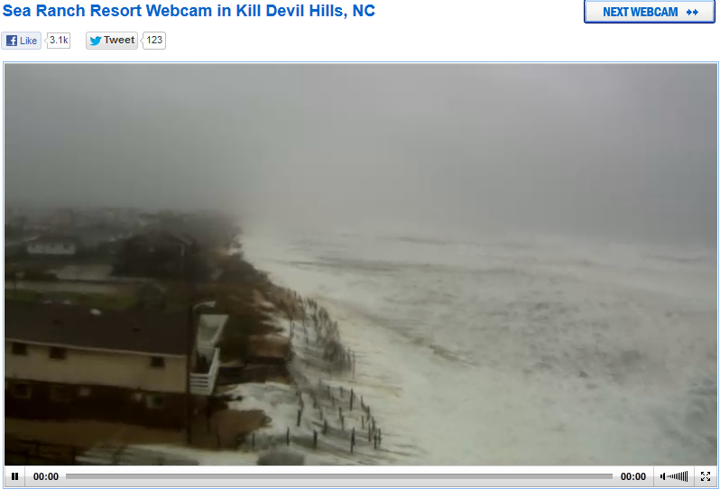
meanwhile and finally, nowhere near the center of Sandy - Kill Devil Hills, NC at high tide. be safe all!