"Irma appears to have weakened a little during the last several
hours. The eye has become cloud filled once again, and the
convective pattern is not as impressive as it was yesterday. A
blend of the latest Dvorak classifications from TAFB/SAB and
ADT values from CIMSS at the University of Wisconsin support
lowering the initial wind speed a little to 95 kt. It is
interesting to note that a ship (BATFR17) passed within 50 n mi to
the west of the center of Irma and has only reported winds of
about 40 kt, indicating that the core of Irma is compact.
The observed fluctuations in strength during the past day or so are
likely to continue for about another day while Irma remains over
marginally warm waters and in fairly close proximity to dry air.
Eyewall replacement cycles, like the one observed yesterday,
could occur, but forecasting the timing and duration of these are
not possible. After 24 hours, Irma is expected to move over
progressively warmer waters and into a more moist environment.
These more favorable conditions combined with low to moderate wind
shear should allow the hurricane to strengthen. The NHC intensity
forecast follows the consensus aids HCCA and IVCN, and it is fairly
similar to the previous advisory.
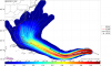
Irma is now moving due west at 12 kt. A subtropical high pressure
system to the north of the hurricane is expected to strengthen and
build westward during the next couple of days. This pattern should
cause Irma to move west-southwestward during that time. Thereafter,
a turn back to the west and then west-northwest is predicted in the
3-5 day time period when Irma moves on the south and southwest sides
of the high. Although the models agree on the overall scenario,
there remains about 200 n mi north-south spread among the
best-performing models on day 5. The NHC track forecast has been
adjusted to the south at the longer-range points, and it is about
halfway between the latest runs of the GFS and ECMWF models.
KEY MESSAGES:
1. Irma is expected to be a major hurricane when it moves closer to
the Lesser Antilles early next week, producing rough surf and rip
currents. Irma could also cause dangerous wind, storm surge, and
rainfall impacts on some islands, although it is too soon to specify
where and when those hazards could occur. Residents in the Lesser
Antilles should monitor the progress of Irma through the weekend and
listen to any advice given by local officials.
2. It is much too early to determine what direct impacts Irma will
have on the continental United States. Regardless, everyone in
hurricane-prone areas should ensure that they have their hurricane
plan in place, as we are now near the peak of the season."
ha ha my topic is already wrong - the core is quite small, still...but given some longevity and better conditions, ...