TS Sandy

texan

Well-Known Member
Hope this does not hit the US.

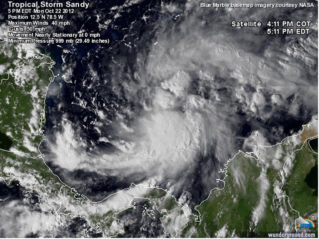
By Friday, Sandy should be in the Central or Eastern Bahamas, and wind shear may increase further, making
Sandy more of a hybrid subtropical storm. It is unclear at this point whether or not the trough pulling Sandy
to the north will be strong enough to pull the storm all the way out to sea to the northeast; a very complicated
steering environment will develop late this week, and it is possible that a narrow ridge of high pressure
could build in over Sandy, and force the storm to the northwest, with a potential threat
to the Northwestern Bahamas and U.S. East Coast by Saturday, as predicted by the ECMWF model
oct22_sandy.jpg

Dr. Jeff Masters' WunderBlog : Sandy forms south of Jamaica; TD 19 forms in middle Atlantic | Weather Underground
 

UnconTROLLed

perfection
TS Sandy should strengthen over the next 24hr. Maybe some rapid intensification late today through tomorrow am.

The most important features in the track of Sandy are the retrograding ocean low across the N Atlantic, and the PNA ridging/ AK vortex. These are all coming into play between D3-4, and the data is simply too sparse and truncated by that point to be confident in either of the above features.

by D5-7, it's a crapshoot.

One important rule in forecasting is to weigh forecasts towards data trends. All of yesterdays 12z and now 0z models trended weaker with the PNA ridging, stronger with AK vortex. Nearly all of 'em trended east with Sandys track. That is telling and if that trend continues another few cycles, Sandy is nothing more than a fish for Bermuda to deal with.

Having said that, it's still early. ;)
 

menotyou

bella amicizia
TS Sandy should strengthen over the next 24hr. Maybe some rapid intensification late today through tomorrow am.

The most important features in the track of Sandy are the retrograding ocean low across the N Atlantic, and the PNA ridging/ AK vortex. These are all coming into play between D3-4, and the data is simply too sparse and truncated by that point to be confident in either of the above features.

by D5-7, it's a crapshoot.

One important rule in forecasting is to weigh forecasts towards data trends. All of yesterdays 12z and now 0z models trended weaker with the PNA ridging, stronger with AK vortex. Nearly all of 'em trended east with Sandys track. That is telling and if that trend continues another few cycles, Sandy is nothing more than a fish for Bermuda to deal with.

Having said that, it's still early. ;)
It will create a messing couple of days, though.
 

UnconTROLLed

perfection
12z euro shows Sandy rapidly intensify over the gulf stream and punching a hole deep into the stratosphere, hooks NW as it's absorbed by the incoming trof and slams into Block Island RI to Groton, CT. Would be a storm for the ages.

937mb at landfall - 27.67". LOL

Unlikely to happen exactly like that, but that's what it shows.

f144.jpg
f168.jpg
f144.jpg
f168.jpg
 
Last edited:

UnconTROLLed

perfection
And finally, HPC chiming in. This is particularly verbose and specific for a D3-7 HPC discussion.
EXTENDED FORECAST DISCUSSION
NWS HYDROMETEOROLOGICAL PREDICTION CENTER COLLEGE PARK MD
329 PM EDT TUE OCT 23 2012

VALID 12Z FRI OCT 26 2012 - 12Z TUE OCT 30 2012


...POTENTIAL FOR MAJOR STORM OVER THE MID ATLANTIC & NORTHEAST
EARLY NEXT WEEK...


PRELIMINARY UPDATE...

UPDATED THE PRELIMINARY FRONTS AND PRESSURES FOR DAYS 3 THROUGH 7
USING THE 00Z/23 EUROPEAN CENTRE ENSEMBLE MEAN, WITH A SMALL
INCORPORATION OF THE 00Z/23 EUROPEAN CENTRE DETERMINISTIC MODEL TO
LEND MORE DEFINITION TO THE SYNOPTIC GRADIENTS ACROSS THE NATION.
USED THE MOST RECENT FORECAST FROM THE NATIONAL HURRICANE CENTER
FOR THE TRACK OF TROPICAL STORM SANDY THROUGH DAY 5, WITH A CURVE
TO THE NORTHWEST DAYS 6 AND 7 BASED ON THE ECENS MEAN.
THE 00Z/23
GEM GLOBAL CONTINUES TO CLUSTER WITH THE ECMWF FOR THE BEHAVIOR OF
SANDY ONCE IT TRANSITIONS TO AN EXTRATROPICAL SYSTEM, INDICATING
THAT THE CYCLONE GETS PULLED BACK TOWARD THE SHARP UPPER TROUGH
CLOSING OVER THE OHIO VALLEY.
THE ECMWF AND GEM GLOBAL HAVE
SEVERAL RUNS OF CONTINUITY NOW WITH THE EVOLUTION OF THIS EVENT,
WITH THE DETERMINISTIC GFS LESS STABLE. THERE HAVE BEEN GFS
ENSEMBLE MEMBERS QUITE SIMILAR TO THE ECMWF/GEM CAMP FOR THE LAST
FEW DAYS OF MODEL CYCLES, PUTTING THE DETERMINISTIC GFS SOLUTIONS
IN A BROADER FRAMEWORK WITH THEIR TRACK OF SANDY WELL OVER THE
OPEN ATLANTIC.
WILL BE UPDATING THE TRACK OF SANDY THROUGH DAY 5
FOR THE FINAL PACKAGE WITH THE ADVENT OF THE NEW NATIONAL
HURRICANE CENTER FORECAST, AND ITS BEHAVIOR AS AN EXTRATROPICAL
LOW THEREAFTER AS PER OUR HOTLINE COORDINATION.


FINAL...

ELECTED TO STAY THE COURSE BY KEEPING THE MAJOR EAST COAST STORM
IN PLAY FOR THE FINAL FORECAST. THE 12Z/23 DETERMINISTIC GFS SENDS
SANDY'S CIRCULATION OUT PAST BERMUDA BY THE END OF THE PERIOD,
WHILE THE 12Z/23 GEFS MEAN INCORPORATES IT ALONG THE EAST COAST IN
LINE WITH THE HPC MANUAL FORECAST. THE 12Z/23 GEM GLOBAL KEEPS
SANDY OUT OF REACH OF THE DIGGING TROUGH OVER NORTH AMERICA,
THOUGH LIKE THE LATEST GFS, IT IS PERHAPS BEST TO REGARD SUCH A
DETERMINISTIC SOLUTION AS A SLIGHTLY SOUPED-UP ENSEMBLE MEMBER.
THE 12Z/23 ECMWF STILL INCORPORATES AN EXTREMELY DEEP
POST-TROPICAL SANDY INTO THE MID-LEVEL PIVOT POINT OF THE POLAR
JET IN THE VICINITY OF LONG ISLAND EARLY NEXT TUESDAY, THE DYNAMIC
TRANSFER RESULTING IN A MINIMUM PRESSURE OF AT LEAST 932MB.
THEREIN LIES THE STORM'S MENACE- A POWERHOUSE CAPABLE OF WHIPPING
THE ATLANTIC INTO A FRENZY AND CHURNING UP DANGEROUS TIDES. OF
PARTICULAR NOTE IS THE COINCIDENCE OF THE FULL MOON ON SUNDAY,
OFTEN A SIGNIFICANT FACTOR IN HISTORICAL EVENTS.
THE OCEAN EFFECTS
OF THE SYSTEM MAY STILL BE REALIZED EVEN IF POST-TROPICAL SANDY
DOES NOT MAKE LANDFALL IN THE UNITED STATES. BESIDES THE WIND, THE
OTHER SENSIBLE WEATHER THREAT IS HEAVY RAINS, WITH HEAVY SNOWS
POSSIBLE ON THE SOUTHWEST SIDE OF THE HYBRID CIRCULATION WHERE
CONTINENTAL POLAR AIR RUSHES ACROSS THE CENTRAL APPALACHIANS.

HAVE PREFERRED THE EUROPEAN CENTRE GUIDANCE FOR HANDLING OF THE
MAIN BAND OF WESTERLIES FOR SEVERAL DAYS NOW, ITS SYNOPTIC NUANCES
BEST SERVING THE CENTRAL AND WESTERN UNITED STATES WHERE THE FLOW
OPENS UP IN THE WAKE OF THE AMPLIFICATION OF THE EASTERN TROUGH.


CISCO
 

UnconTROLLed

perfection
This is from EVT, BOX NWS office.
Exactly right.

One never knows what will happen. Yes, the EC has been remarkably consistent this far out, but one little perturbation 6 days out can really make a big change.

Having said that, I'm REALLY worried, and I'm the long term forecaster at BOX tonight (sigh...).

--*****
 

texan

Well-Known Member
Sandy a potential threat to New England
By Friday, Sandy should be over warm waters in the Central Bahamas, but only modest re-intensification by
10 - 20 mph should occur, due to high wind shear.

At that point, a very complicated meteorological situation unfolds, as Sandy interacts with a trough of low pressure
approaching the U.S. East Coast. The trough may steer Sandy northeastwards, out to sea, as predicted by the
GFS, HWRF, and GFDL models.

However, an alternative solution, shown by the ECMWF and NOGAPS models, is for the trough to inject a
large amount of energy into Sandy, converting it to a powerful subtropical storm that hits New England
early next week with a central pressure of 948 mb and winds near hurricane-force.

The ECMWF and NOGAPS models are off by a full day in their predictions of when the storm would
arrive, with the 06Z NOGAPS model predicting Sandy's heavy rains will arrive on North Carolina's Outer Banks on
Sunday, then spread into the mid-Atlantic and New England on Sunday.

The 00Z ECMWF model forecast predicts that Sandy will arrive in New England on Monday night.
Dr. Jeff Masters' WunderBlog : Sandy intensifying, headed towards Jamaica | Weather Underground
 

texan

Well-Known Member
Sandy: a potential billion-dollar storm for the mid-Atlantic, New England, and Canada

The latest set of 12Z (8 am EDT) model runs are in, and they portray an increased risk to the U.S. and Canadian East
Coasts for early next week. The GFS model, which had been showing that Sandy would head to the northeast out to
sea, now has changed its tune, and predicts that Sandy will double back and hit Maine on Tuesday evening.

The ECMWF model, which has been very consistent in its handling of Sandy, now has the storm hitting Delaware
on Monday afternoon. These models are predicting that Sandy will get caught up by the trough approaching
the Eastern U.S., which will inject a large amount of energy into the storm, converting it to a powerful
subtropical storm with a central pressure below 960 mb and sustained winds of 60 - 70 mph.

Winds of this strength would likely cause massive power outages, as trees still in leaf take out power lines.
Also of great concern are Sandy's rains.
Dr. Jeff Masters' WunderBlog : Hurricane Sandy hits Jamaica, dumps heavy rains on Haiti | Weather Underground


UnconTROLLed

perfection
Huge potential, 1 in 100 to 500 year analogous potential. We'll see if it's realized.

Interestingly the 18z GEFS ensemble mean shifted east , as well as most individual members. The gfs is notorious for progressive bias, however the ensemble play is a little disconcerting.
 
Top